Discover the Future of Roof Surveys: How Drones are Revolutionizing the Industry
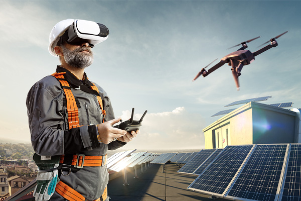
Drone surveys have revolutionized the roofing industry in numerous ways. They offer the significant benefit of safety, as they eliminate the need for manual inspections that often involve potential fall hazards. Drone surveys are also highly efficient, reducing the time required for roof assessments from a few days to mere hours. These surveys provide precise and comprehensive data that can be easily analyzed and interpreted, ensuring a higher level of accuracy in identifying potential issues. They also allow for regular monitoring and maintenance, helping to spot minor issues before they develop into significant problems. Finally, drone surveys are environmentally friendly, reducing the carbon footprint associated with traditional roof surveying methods.
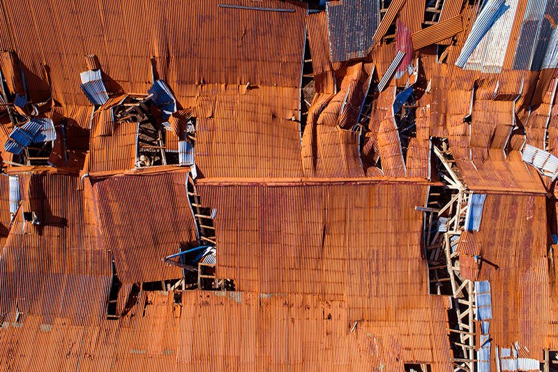
As the technology continues to advance and become more affordable, drone surveys are becoming increasingly popular in the roofing industry. They have proven to be a game-changer for roof inspections, providing detailed and high-quality images of roofs that were previously inaccessible or difficult to inspect. With their ability to capture both visual and thermal data, drone surveys provide a comprehensive overview of the condition of a roof, helping roofing professionals make more informed decisions and recommendations to their clients.
The Key Advantages of Drone Surveys in Roofing Industry
One of the most significant advantages of drone surveys is their ability to access hard-to-reach areas. Drones can navigate through tight spaces and maneuver around obstacles, providing a comprehensive view of every inch of a roof. This eliminates the need for workers to physically climb onto roofs or use expensive equipment like scaffolding or cranes, reducing the risk of accidents and injuries. Additionally, drones can fly at different elevations and angles, providing a more accurate assessment of the overall condition of a roof.
Another benefit of drone surveys is their cost-effectiveness. Traditional methods of roof inspections often require significant manpower and resources, resulting in high costs for clients. With drone surveys, only one operator is needed to control the drone, and the data can be captured and processed quickly. This not only reduces costs for clients but also saves time, allowing roofing professionals to inspect multiple roofs in a shorter amount of time.
In addition to saving time and money, drone surveys also offer more accurate results. The use of thermal imaging technology allows drones to detect heat anomalies or moisture intrusion on a roof, which may not be visible to the naked eye. This helps identify potential issues before they become major problems, preventing costly repairs or replacements in the future.
Moreover, drone surveys provide an efficient and non-intrusive way to inspect roofs. Traditional methods of roof inspections often involve large equipment and disruptions to daily operations. With drones, the process is much less intrusive as the drones can fly over a roof without causing any disturbances. This is particularly beneficial for businesses or organizations that cannot afford to shut down operations for extended periods.
Additionally, drone surveys are environmentally friendly compared to traditional methods of roof inspections. Drones do not emit harmful gases or produce loud noises like other equipment used in traditional roof inspections, making them a more eco-friendly option.
Thermal Cameras Have Significant Advantages
In drone roof surveys, thermal cameras are deployed in a strategic manner to capture comprehensive data. Typically, the thermal camera is mounted on the drone, and the drone operator pilots it to fly over the roof. The thermal camera then captures infrared radiation from the objects on the roof surface, which varies according to the temperature and material properties of the objects. This infrared data is translated into visual images, commonly known as thermograms. These thermograms are then interpreted and analyzed to identify areas with temperature anomalies indicating potential issues such as heat loss, moisture intrusion, or insulation gaps. This process provides a reliable, non-contact method for detecting and diagnosing roof issues, even those which may not be visible to the naked eye.
The Key Disadvantages of Drone Surveys in Roofing Industry
Despite the numerous advantages, drone surveys have their share of limitations. One of the primary constraints is their dependence on weather conditions. Drones cannot operate effectively in extreme weather, such as high winds, heavy rain, or snow. This can delay roof inspections and potentially prolong the detection of serious issues.
Another drawback is the limited battery life of drones. Drones typically have a flight duration of 20 to 30 minutes depending on the model, which may not be sufficient for surveying larger structures or complex roofs.
Drone surveys also require a skilled operator to control the drone and interpret the data. Although drone technology has become more user-friendly, there is still a learning curve involved, and unskilled handling can lead to inaccurate data or even damage to the drone itself.
Lastly, there are privacy concerns associated with the use of drones. People may feel uncomfortable with drones flying over their property, and in some areas, there may be regulations restricting the use of drones. These factors must be taken into consideration when performing drone surveys.
Examples of Successful Drone Survey Projects
One notable instance of effective drone use is the roof survey of the historic Boston City Hall in 2016. Conducted by the company PrecisionHawk, the drone survey was not only faster and less expensive than a traditional survey, but it also provided detailed imagery that helped the city plan for future maintenance and restoration work.
Another successful project was carried out by the drone services company, Skyward, for a commercial real estate firm. The firm needed detailed information about the roof conditions of several properties before purchasing. Thanks to the drone survey, they were able to promptly receive high resolution images and 3D models of the roofs, helping them make an informed decision much faster than traditional methods would allow.
In 2019, the Royal National Lifeboat Institution (RNLI) and the Maritime and Coastguard Agency (MCA) in the UK, jointly ran a pilot scheme using drones for search and rescue operations. The project demonstrated how drones can provide vital information faster and safer, especially in locations difficult for humans to reach.
These instances clearly illustrate the powerful impact of drone surveys in various sectors, from architectural preservation and real estate to emergency and rescue operations.
Common Misconceptions about Drone Surveys
Contrary to popular belief, drone surveys are not simply a matter of flying a drone and collecting data. There’s a common misconception that drones are easy to fly. However, operating a drone, especially for surveying purposes, requires technical knowledge, training, and experience.
Another frequent misunderstanding is that drone surveys are expensive. In reality, while the initial investment for a high-quality, survey-grade drone may be significant, the cost savings over time are substantial due to the reduction in manpower, time, and resources compared to traditional survey methods.
Lastly, some people might think the data captured by drones is not as reliable or accurate as data from ground-based surveys. This is not true. Drone technology has greatly advanced, and with the aid of sophisticated software, drones can deliver highly accurate data, often surpassing the precision of traditional methods.
Software and Roof Inspection Analysis
The advent of advanced software applications has significantly transformed the way roof inspections are conducted. Software specifically designed for drone-based roof inspections can convert the raw data captured by drones into actionable insights. Not only can it create high-resolution 3D models of the roof, but it can also identify anomalies such as leaks, dampness, or structural damage that might be invisible to the naked eye. Furthermore, some programs can even estimate the extent of the damage, thereby providing a basis for repair estimates. This level of detail facilitates a more efficient and accurate assessment of the roof’s condition, thereby enabling targeted and timely interventions. Additionally, the use of software eliminates the risks associated with manual roof inspections, making the process safer and more efficient.
Following are some of the software tools commonly used by industry experts for drone-based roof inspections:
- DroneDeploy: This software offers a powerful range of features including flight planning, 3D modeling, and detailed damage reports. It’s a favorite for many professionals in the industry due to its user-friendly interface and comprehensive capabilities.
- Pix4D: Widely known for its advanced photogrammetry capabilities, Pix4D allows users to capture high-quality, georeferenced images, create 3D models, and measure distances, areas, and volumes.
- Skyward: More than just a flight app, Skyward provides end-to-end solutions for managing drone operations, including flight logging, equipment management, and personnel tracking.
- SenseFly eMotion: Specifically designed for use with SenseFly drones, eMotion software offers intuitive flight planning, simplified data collection, and seamless integration with existing GIS workflows.
- Autodesk ReCap: Used in combination with other tools, Autodesk ReCap allows professionals to create 3D models from drone-captured images, which can be used for in-depth analysis and planning.
Imagineer, with its extensive industry experience and technical prowess, stands out as a leader in executing drone-based roof inspections through seamless integration with all third-party solutions. Our team is proficient in utilizing a broad spectrum of software tools, including but not limited to DroneDeploy, Pix4D, Skyward, SenseFly eMotion, and Autodesk ReCap. We leverage these resources to capture high-quality, georeferenced images, create detailed 3D models, and generate comprehensive damage reports to provide our clients with the most accurate and efficient roof assessments. Regardless of the specific software involved, you can rely on Imagineer’s expertise to deliver exceptional results.
Unparalleled Skills of Imagineer Pilots
Experienced drone roof survey pilots, such as those at Imagineer, employ a variety of strategies to overcome the typical limitations associated with drone surveys. To mitigate weather dependency, pilots keep a close eye on weather forecasts and strategically schedule flight times to ensure optimal conditions, thereby minimizing delays.
As for the constraint of limited battery life, Imagineer pilots always have backup batteries on hand and are adept at maximizing flight efficiency to cover extensive areas within a single flight duration. They also employ drones that offer extended flight times compared to standard models, thus enabling them to survey larger structures or complex roofs without interruption.
Regarding the need for skilled operators, Imagineer boasts a team of certified pilots proficient in both drone control and data interpretation. Continuous training and staying abreast with the latest advancements in drone technology enables them to ensure accurate data collection, thereby negating the risks associated with unskilled handling.
In terms of privacy concerns, Imagineer pilots uphold the highest standards of professionalism, always respecting privacy and adhering strictly to local regulations. They ensure clear communication with property owners and obtain necessary permissions, thereby guaranteeing smooth and compliant operations.
The expertise of Imagineer pilots truly sets them apart in the drone survey industry. Equipped with extensive training and unparalleled proficiency in drone control and data interpretation, they ensure accuracy and efficiency in every operation. Their keen understanding of drone technology, combined with the ability to continuously adapt to its latest advancements, guarantees precise data collection and negates the risks associated with unskilled handling. Beyond technical skills, Imagineer pilots also exhibit remarkable professionalism. They respect privacy, strictly adhere to local regulations, and maintain open communication with property owners, ensuring smooth, compliant operations. Ultimately, the skills and dedication of Imagineer pilots contribute to the high-quality, reliable results that the company is known for.
Beyond technical skills, Imagineer pilots also exhibit remarkable professionalism. They respect privacy, strictly adhere to local regulations, and maintain open communication with property owners, ensuring smooth, compliant operations. Ultimately, the skills and dedication of Imagineer pilots contribute to the high-quality, reliable results that the company is known for.
How long does an aerial roof inspection take?
The duration of a drone roof inspection can vary significantly based on several factors. For instance, a small residential property, around 200 square meters, can typically be surveyed in under an hour, assuming favorable weather conditions and no significant geographical or regulatory constraints.
Conversely, larger commercial properties, spanning several thousand square meters, might require several hours, or even multiple days to fully inspect. This can be attributed to the increased complexity of commercial properties, which might necessitate more detailed inspections of specific areas.
Weather is another critical determinant. Optimal conditions — mild temperatures and clear skies — allow for efficient operations, while adverse conditions like rain, snow, or high winds can delay or extend the inspection significantly.
Wind speed, in particular, is a crucial consideration. Even a light breeze can affect a drone’s stability and control, potentially compromising the quality of the data collected.
Geo-fencing and airspace restrictions can also factor into the inspection duration. In areas with strict flight restrictions or near sensitive installations (airports, military bases, etc.), additional time might be needed to obtain necessary permissions and ensure compliance with all regulations.
Thus, while drone inspections offer a faster, more efficient alternative to traditional methods, the precise duration can be influenced by a multitude of factors, all of which are taken into account by our skilled Imagineer pilots to ensure high-quality, reliable results.
Addressing Client Concerns
At Imagineer, we understand that potential clients may have concerns about the use of drone surveys. We want to assure you that we prioritize transparency and communication throughout the entire process. Our team of professionals is on hand to answer any questions regarding safety, data privacy, and legal compliance.
Ensuring Safe Operations
For safety concerns, know that our drones have built-in safety features, such as automatic return home on low battery or signal loss. This ensures that our operations are safe and risk-free.
Data Privacy and Security
In terms of data privacy, we only collect necessary data for the survey and handle this data with the utmost care. All data collected is processed in accordance with the highest standards of data privacy and security.
Legal Compliance in Operations
Lastly, regarding legal compliance, we thoroughly research and conform to all local and federal regulations on drone usage. Before we conduct any surveys, we acquire all necessary permits and approvals.
Get in Touch
Remember, your satisfaction and peace of mind are our top priority. Should you have any further questions or concerns, please do not hesitate to reach out to us.